
Indonesia's 2026 Peatland Fires Intensify Amid Severe Drought and El Niño
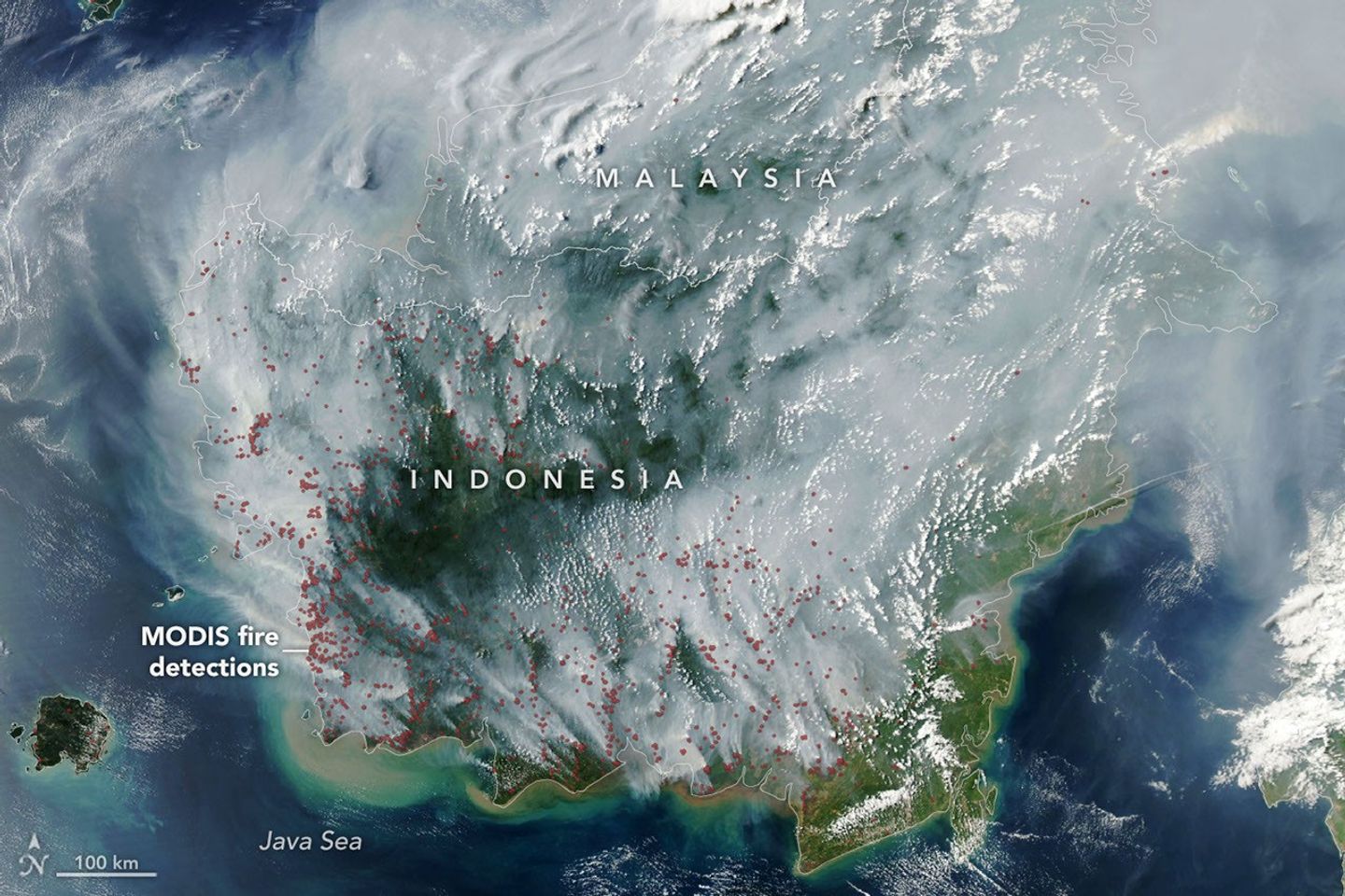
In 2026, Indonesia experienced severe peatland fires across Kalimantan and Sumatra, fueled by worsening drought conditions linked to a strengthening El Niño phenomenon, rising temperatures, and degradation of millions of hectares of peatlands. Peat fires, burning underground in carbon-rich wetland soils, are particularly damaging and difficult to extinguish. Satellite data from NASA's MODIS sensors and Indonesia's fire-monitoring platforms revealed a sharp rise in fire hotspots. The fires caused widespread haze, respiratory health issues, and led to law enforcement actions against suspected arsonists and companies involved in land clearing. These events highlight the environmental and public health challenges Indonesia faces, especially during El Niño episodes, making peatland fires a crucial topic for competitive exams focusing on environment and current affairs.
On this page
Key Facts
- Peat fires burn underground in carbon-rich wetland soils, often smoldering for months until rains arrive.
- Indonesia holds about 36% of the world's tropical peatlands, mainly in Sumatra, Kalimantan, and Papua islands.
- El Niño is a periodic warming of the central and eastern Pacific Ocean causing reduced rainfall and drought across Indonesia.
- In early August 2026, approximately 90% of Indonesia experienced little to no rainfall due to a strong El Niño event.
- NASA's Aqua satellite, featuring the MODIS sensor, detected numerous thermal anomalies and smoke plumes indicating active peat fires.
- The 2026 peat fires released around 10% of the greenhouse gas equivalent emitted during Indonesia's severe 2015 fire season.
- Law enforcement arrested 72 individuals suspected of deliberately starting fires and investigated 19 companies linked to agricultural land clearing on burned peatland areas.
- Heavy haze caused by peat fires led local authorities to close schools and issue health warnings due to toxic gases and particulate pollution affecting respiratory health.
Background & Context
Peatlands are waterlogged ecosystems composed of partially decomposed plant material, storing large amounts of carbon. Indonesia's peatlands have increasingly been degraded and drained for agriculture, especially palm oil plantations, heightening their vulnerability to fires.
Normally, these peat soils remain too wet to burn underground. However, during drought conditions intensified by El Niño, peatlands dry sufficiently to support persistent underground fires that can last for months and are difficult to detect via satellites due to smoke and forest canopy cover.
The 2026 fire season parallels the catastrophic 2015 peat fire event, which emitted massive greenhouse gases and caused regional haze affecting millions. Satellite-based monitoring using instruments like MODIS and VIIRS, through platforms such as Indonesia's SiPongi, support near-real-time fire detection despite inherent limitations.
Why This Matters for Exams
Understanding the causes and impacts of Indonesia's 2026 peat fires is crucial for subjects dealing with environment, climate science, geography, and current affairs. The link between El Niño, drought, land use practices, and peat fire dynamics exemplifies complex environmental challenges in Southeast Asia.
Students should be familiar with satellite monitoring technologies like MODIS and VIIRS, international and local fire management efforts, and the environmental, health, and socio-economic consequences of prolonged peat fires.
Points to Remember
- Peat fires burn underground and can smolder unseen for months, releasing large amounts of greenhouse gases.
- El Niño events reduce rainfall, drying peat soils and enhancing fire risk in Indonesia.
- Indonesia’s 2026 fire season, though less severe than 2015, shows significant environmental strain and public health repercussions.
- Satellite systems such as MODIS and VIIRS are critical for tracking widespread fire activity, despite detection challenges.
- Legal action against arsonists and companies linked to intentional burning reflects ongoing governance efforts.
- Peat fire smoke causes toxic haze, impacting respiratory health and forcing measures like school closures.
Practice MCQs
Question 1
- 2018
- 2015
- 2026
- 2010
Answer: 2015
Question 2
- MODIS - Moderate Resolution Imaging Spectroradiometer
- VIIRS - Visible Infrared Imaging Radiometer Suite
- SiPongi - Indonesian Ministry of Forestry Fire Monitoring Platform
- All of the above
Answer: All of the above
Question 3
- 90%
- 50%
- 10%
- 75%
Answer: 90%
Sources & Further Reading
| Document / Website | Link |
|---|---|
| Indonesia’s Peat Fires Intensify Amid El Niño – GKToday | Open Indonesia’s Peat Fires Intensify Amid El Niño – GKToday ↗www.gktoday.in |
| Peatland Fires Darken Skies in Indonesia - NASA Science | Open Peatland Fires Darken Skies in Indonesia - NASA Science ↗science.nasa.gov |
| Indonesia fires: Toxic haze spreads across South East Asia amid 'super' El Niño | Open Indonesia fires: Toxic haze spreads across South East Asia amid 'super' El Niño ↗www.bbc.com |